One of the big strides in Coastal Surveillance.
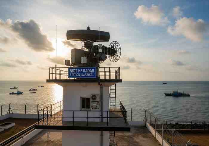
The National Institute of Ocean Technology (NIOT) has plans to deploy a high-frequency (HF) radar in the Karaikal area of Puducherry.
The purpose of the project is to enhance ocean real-time monitoring. It will also enhance weather prediction and early warning of cyclone and extreme weather events.
Karaikal Strategic Location.
NIOT has chosen two sites based on thorough research:
These locations give the most favorable environment in gathering correct data in the ocean. The project will be part of a bigger plan to extend monitoring system along the eastern coast of India.
How HF Radar Works
The ocean surface is studied in real time by high-frequency radar.
It can:
- Measure ocean currents
- Track wave movement
- Check wind and temperature variations.
The system has the capability of monitoring to 200 km offshore. It is able to detect weather variations in a range of 80-100km. This can be of great use in early warnings.
Improved Coastal Observation
The new radar will be able to gather significant information in the form of:
- Present velocity and direction.
- Heights and patterns of waves.
- Wind pressure
- Temperature variations
This information assists researchers in enhancing weather forecasting. It also helps in improved prediction of cyclones and storms.
Connection with Existing Network.
Karaikal radar will collaborate with an existing radar station in Cuddalore.
Such a pairing system will:
- Enhance information precision.
- Do a better mapping of ocean currents.
- Enhance the coastal surveillance system.
These systems will provide a better understanding of the state of the oceans together.
Weather Forecasting.
The information will be shared with the important agencies:
- Indian National Centre Ocean Information Services.
- India Meteorological Department
The data are used by these agencies to:
- Predict cyclones
- Issue coastal warnings
- Educate fishermen and communities.
This enhances safety and minimizes risks of disasters.
Role under Blue Economy.
The project assists in the objectives of Blue Economy in India. It is included in a collaboration plan between the Ministry of Earth Sciences and Puducherry.
Benefits include:
- Better fisheries management
- Conservation of the ocean ecosystems.
- Marine planning support.
It also aids in sustainable exploitation of ocean resources.
Why This Project is Important.
Cyclones tend to occur along the eastern coast of India. Good monitoring systems are crucial.
This radar system will:
- Enhance early warning systems.
- Enhance disaster preparedness
- Support scientific research
It will also assist the local communities to remain safe and aware.
Exam-Focused Points
- NIOT to set up HF radar in Karaikal (Puducherry).
- Radar checks on currents, waves, wind and temperature.
- A 200 km offshore coverage.
- Detection range: 80–100 km.
- Radar station in Cuddalore.
- Favors prediction of cyclones and safety of coasts.
- Information exported to INCOIS and IMD.
- Associated with Blue Economy and Ministry of Earth Sciences.
Month: Current Affairs - May 01, 2026
Category: Oceanography and Disaster