NIOT’s Floating LiDAR Innovation Boosts Offshore Wind & Climate Studies
India has achieved a significant technological breakthrough with the successful testing of an indigenously developed Floating LiDAR Buoy System by the National Institute of Ocean Technology. The test, conducted off the coast of Muttom, marks a major advancement in ocean observation and atmospheric data collection for offshore environments.
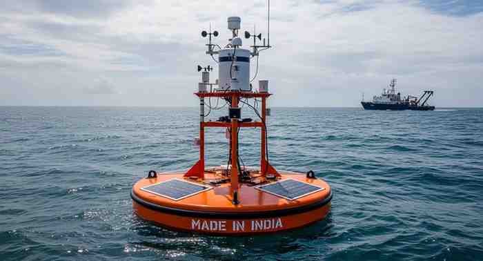
What is Floating LiDAR Buoy System?
The Floating LiDAR Buoy System is a sophisticated marine-based instrument designed to measure wind characteristics over oceans. It integrates a floating buoy platform with LiDAR (Light Detection and Ranging) technology, which uses laser pulses to capture detailed atmospheric data such as wind speed, direction, and vertical variations above sea level.
Working Mechanism of the System
The system functions by emitting laser beams into the atmosphere from a buoy positioned on the ocean surface. These beams interact with airborne particles and reflect back to the sensor. By analysing the returned signals, scientists can accurately determine wind profiles and atmospheric conditions. The system can measure wind data up to 300 metres above sea level, offering more precise and real-time insights compared to conventional methods.
Key Features and Advantages
This innovation provides continuous monitoring in remote offshore areas where fixed infrastructure is difficult to establish. Its ability to generate high-resolution vertical wind profiles makes it particularly valuable for offshore wind energy projects. Additionally, the indigenous development reduces reliance on foreign technologies, supporting India’s self-reliance in advanced scientific instrumentation.
Significance for Weather and Climate Studies
The Floating LiDAR Buoy System is expected to improve weather forecasting and enhance cyclone tracking in coastal regions. It also contributes to better understanding of climate change and ocean-atmosphere interactions. By delivering real-time marine wind data, the system strengthens India’s capabilities in disaster management, renewable energy planning, and environmental monitoring.
Exam-Focused Points
-
Developed by National Institute of Ocean Technology (NIOT) .
-
Uses LiDAR (Light Detection and Ranging) technology.
-
Measures wind profiles up to 300 metres above sea level .
-
Tested near Muttom, Tamil Nadu .
-
Useful for offshore wind energy planning .
-
Enhances cyclone prediction and weather forecasting .
-
Supports Atmanirbhar Bharat in scientific technology .
Month: Current Affairs - March 18, 2026
Category: Science & Technology, Environment